


Pont de Montvert - Florac

nolsim
User
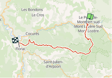

Length
27 km

Max alt
1420 m

Uphill gradient
890 m
Km-Effort
40 km

Min alt
537 m

Downhill gradient
1234 m
Boucle
No
Creation date :
2018-08-18 14:08:56.185
Updated on :
2018-08-18 14:08:56.185
--
Difficulty : Medium

FREE GPS app for hiking
 SityTrail
IGN / Geographical institutes
SityTrail Plus
The world is yours!
About
Trail Walking of 27 km to be discovered at Occitania, Lozère, Pont de Montvert - Sud Mont Lozère. This trail is proposed by nolsim.
Positioning
Country:
France
Region :
Occitania
Department/Province :
Lozère
Municipality :
Pont de Montvert - Sud Mont Lozère
Location:
Le Pont-de-Montvert
Start:(Dec)
Start:(UTM)
558876 ; 4912552 (31T) N.
Comments